Log in
All resources
Create a design
306 Free Artworks of 1600 Maps
bibliothèque nationale de france
maps by pieter van der keere
cosmographia (1600) by sebastian münster
maps of cairo by braun & hogenberg
maps by willem and johannes blaeu
maps by pieter mortier
map of vienna by jacob hoefnagel
vienna in the 1600s
jacob hoefnagel
maps by jodocus hondius
1600s maps of mecklenburg-vorpommern
maps of rügen by eilhard lubinus
maps by pieter van der keere
old maps of north brabant
1570s maps of africa
1570s maps of egypt
cosmographia (1600) by sebastian münster
maps of cairo by braun & hogenberg
historical images of graben (vienna)
map of vienna by jacob hoefnagel
parts of old maps of hamburg
maps of hamburg-altstadt
maps by girolamo porro
1598 maps of russia
abraham cresques
catalan atlas
cosmographia (1600) by sebastian münster
maps of cairo by braun & hogenberg
old maps of nassau
salomon rogiers
cosmographia (1600) by sebastian münster
maps of cusco by braun & hogenberg
maps by girolamo porro
1598 maps of russia
maps by girolamo porro
1598 maps of russia
maps of the ottoman empire by mercator-hondius
eran laor cartographic collection
maps of the ottoman empire by mercator-hondius
eran laor cartographic collection
hamburg in the 16th century
maps of hamburg-altstadt
cosmographia (1600) by sebastian münster
maps of cairo by braun & hogenberg
cosmographia (1600) by sebastian münster
maps of cairo by braun & hogenberg
the generall historie of virginia (john smith)
1624 engravings
cosmographia (1600) by sebastian münster
maps of cairo by braun & hogenberg
cosmographia (1600) by sebastian münster
maps of cairo by braun & hogenberg
17th-century maps of southeast asia
maps by girolamo porro
17th-century maps of xaintonge
maps by jodocus hondius
maps of augsburg by braun & hogenberg
1600s maps of augsburg
17th-century maps of the british isles
maps by abraham ortelius
cosmographia (1600) by sebastian münster
maps of cusco by braun & hogenberg
cosmographia (1600) by sebastian münster
maps of cusco by braun & hogenberg
17th-century maps of mecklenburg-vorpommern
maps of rügen by eilhard lubinus
arnold van langren map of east africa
1600 maps of africa
17th-century maps of the mediterranean sea
ships on maps
17th-century maps of bremen (state)
1600s maps of lower saxony
old maps of westphalia
johannes gigas
maps by jodocus hondius
old maps of nassau
maps by pieter van der keere
maps with cartouches
17th-century maps of switzerland
maps by pieter van der keere
köln-weidenpesch
köln-nippes
maps by pieter van der keere
maps by abraham ortelius
1600s maps of the world
copper engravings
1640s maps of hesse
old maps of nassau
1600s maps of lower saxony
maps by abraham ortelius
old maps of the tribes of israel
guillaume sanson
maps by pieter mortier
maps from gallica
maps of the magellan straits by lambert cornelis
bibliothèque nationale de france
old maps of the republic of genoa
maps by willem and johannes blaeu
admiralty charts region b: england wales ireland english channel southern north sea
admiralty charts 1401-1600
17th-century maps of africa
maps from gallica
17th-century maps of the netherlands
maps by pieter van der keere
17th-century maps of xaintonge
maps by jodocus hondius ii
maps by pieter mortier
maps from gallica
parts of old maps of cologne
cologne in the 1600s
münster-holzschnitt trier
martinskloster (trier)
1600 maps of africa
benjamin wright
maps by willem and johannes blaeu
1680s maps of brazil
maps by hendrik hondius the younger
maps of the duchy of milan
maps by pieter mortier
maps from gallica
maps of saint paul's journeys
maps by pieter van der keere
parts of old maps of bremen
bremen in the 1600s
ambrosio spinola, marqués de los balbases
karel bonaventura buquoy
map of vienna by jacob hoefnagel
stubenbrücke
map of vienna by jacob hoefnagel
drawings of churches
maps of ancient italy by philipp clüver
old maps of the history of liguria
old maps of the rhine
neuburg am rhein
maps by pieter van der keere
old maps of bohemia
maps of aragon and catalonia by mercator-hondius
spain in the 1600s
maps by hendrik hondius the younger
maps of the county of mansfeld
claes jansz. visscher (ii)
maps of amsterdam
maps of ancient italy by philipp clüver
old maps of samnium
dutch 17th-century prints in the rijksmuseum amsterdam
battle of nieuwpoort
magni ducatus lithuaniae
maps facing west
descriptio daciarum (17th-century map)
maps by pieter van der keere
maps of ancient italy by philipp clüver
old maps of marche
flughafen köln-butzweilerhof
köln-bocklemünd/mengenich
maps of the principality of erbach
maps by pieter van der keere
history of westphalia in the lwl-museum für kunst und kultur
maps of arnsberg by braun & hogenberg
1609 works in north rhine-westphalia
abraham hogenberg
1600s maps of the netherlands
1609 maps of europe
maps in the rijksmuseum amsterdam
maps by willem and johannes blaeu
nederlandse en buitenlandse gebeurtenissen
album met 345 prenten van hogenberg
nederlandse en buitenlandse gebeurtenissen
album met historieprenten van hogenberg
eran laor cartographic collection
pieter van der keere
17th-century maps of the holy roman empire
maps by pieter van der keere
maps of liège by baptista van doetecum
maps by abraham ortelius
maps by willem and johannes blaeu
old maps of capitanata
old maps of the western hemisphere
jacob van meurs
maps of portugal by fernando álvares seco
bibliothèque nationale de france
demolished castles in landkreis germersheim
neuburg am rhein
parts of old maps of bremen
bremen in the 1600s
arnold van langren map of southwest africa
renaissance
admiralty charts region b: england wales ireland english channel southern north sea
admiralty charts 1401-1600
philippe de la rué
maps of mysia
maps of japan by mercator-hondius
bibliothèque nationale de france
parts of old maps of bremen
bremen in the 1600s
maps of provence by pierre-jean de bompar
bibliothèque nationale de france
maps of japan by mercator-hondius
bibliothèque nationale de france
maps by willem and johannes blaeu
bibliothèque nationale de france
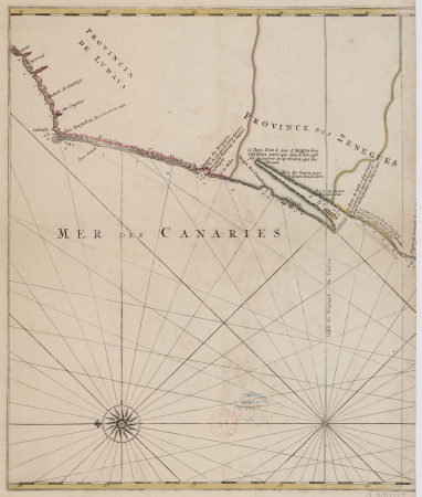
carte particulière des costes de l'afrique qui comprend le royaume de gualata ... - btv1b8595466g
maps by pieter mortier
carte particulière des costes de l'afrique qui comprend le royaume de gualata ... - btv1b8595466g
maps by pieter mortier
historical images of vienna
schottenkirche, vienna
library of the university of vienna
map of vienna by jacob hoefnagel
bibliothèque nationale de france
guillaume sanson
101 - 200 of 306
Next page
/ 4